
Nazca Lines
Introduction from Wikipedia and discovery by Jedi Simon
The Nazca Lines /ˈnæzkə/ are a series of ancient geoglyphs
located in the Nazca Desert in southern Peru. They were designated as a UNESCO
World Heritage Site in 1994. The high, arid plateau stretches more than 80
kilometres (50 mi) between the towns of Nazca and Palpa on the Pampas de Jumana
about 400 km south of Lima. Although some local geoglyphs resemble Paracas
motifs, scholars believe the Nazca Lines were created by the Nazca culture
between 400 and 650 AD. The hundreds of individual figures range in complexity
from simple lines to stylized hummingbirds, spiders, monkeys, fish, sharks,
orcas, and lizards.
The lines are shallow designs made in the ground by removing the reddish pebbles
and uncovering the whitish/grayish ground beneath. Hundreds are simple lines or
geometric shapes; more than seventy are zoomorphic designs of animals such as
birds, fish, llamas, jaguar, monkey, or human figures. Other designs include
phytomorphic shapes such as trees and flowers. The largest figures are over 200
metres (660 ft) across. Scholars differ in interpreting the purpose of the
designs, but in general they ascribe religious significance to them. Other
theories have been summarized as follows:
"The geometric ones could indicate the flow of water or be connected to rituals
to summon water. The spiders, birds, and plants could be fertility symbols.
Other possible explanations include: irrigation schemes or giant astronomical
calendars."
Due to the dry, windless, and stable climate of the plateau and its isolation,
for the most part the lines have been preserved. Extremely rare changes in
weather may temporarily alter the general designs. As of recent years, the lines
have been deteriorating due to an influx of squatters inhabiting the lands.
History
Contrary to the popular belief that the lines and figures can
only be seen with the aid of flight, they are visible from atop the surrounding
foothills. They were first discovered by the Peruvian archaeologist Toribio
Mejia Xesspe, who spotted them when hiking through the foothills in 1927. He
discussed them at a conference in Lima in 1939.[4]
Paul Kosok, a historian from Long Island University, is credited as the first
scholar to seriously study the Nazca Lines. In the country in 1940-41 to study
ancient irrigation systems, he flew over the lines and realized that one was in
the shape of a bird. Another chance helped him see how lines converged at the
winter solstice in the Southern Hemisphere. He began to study how the lines
might have been created, as well as to try to determine their purpose. He was
joined by Maria Reiche, a German mathematician and archaeologist to help figure
out the purpose of the Nazca Lines. They proposed one of the earliest reasons
for the existence of the figures: to be markers on the horizon to show where the
sun and other celestial bodies rose. Archaeologists, historians and
mathematicians have all struggled with determining the purpose of the lines.
Determining how they were made has been easier than figuring why they were made.
Scholars have theorized the Nazca people could have used simple tools and
surveying equipment to construct the lines. Archaeological surveys have found
wooden stakes in the ground at the end of some lines, which support this theory.
One such stake was carbon-dated and was the basis for establishing the age of
the design complex. The scholar Joe Nickell of the University of Kentucky has
reproduced the figures by using tools and technology available to the Nazca
people. The National Geographic called his work "remarkable in its exactness"
when compared to the actual lines. With careful planning and simple technologies,
a small team of people could recreate even the largest figures within days,
without any aerial assistance.
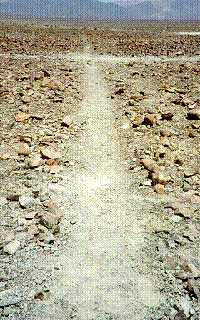
On the ground, most of the lines are formed by a shallow trench with a depth of
between 10 cm (3.9 in) and 15 cm (5.9 in). Such trenches were made by removing
the reddish-brown iron oxide-coated pebbles that cover the surface of the Nazca
desert. When this gravel is removed the light-colored clay earth which is
exposed in the bottom of the trench produces lines which contrast sharply in
color and tone with the surrounding land surface. This sublayer contains high
amounts of lime which, with the morning mist, hardens to form a protective layer
that shields the lines from winds, thereby preventing erosion.
The Nazca "drew" several hundred simple but huge curvilinear animal and human
figures by this technique. In total, the earthwork project is huge and complex:
the area encompassing the lines is nearly 500 square kilometres (190 sq mi), and
the largest figures can span nearly 270 metres (890 ft). Some of the
measurements for the figures include that the Hummingbird is 93 meters (310 ft)
long, the Condor is 134 meters (440 ft), the Monkey is 93 meters (310 ft) by 58
meters (190 ft), and the Spider is 47 meters (150 ft). The extremely dry,
windless, and constant climate of the Nazca region has preserved the lines well.
The Nazca desert is one of the driest on Earth and maintains a temperature
around 25 °C (77 °F) all year round. The lack of wind has helped keep the lines
uncovered and visible to the present day.
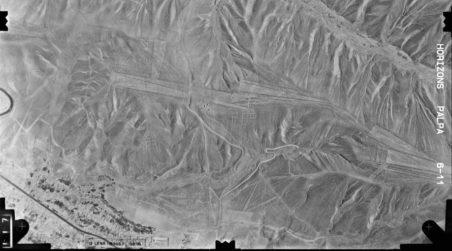
The discovery of two new small figures was announced in early 2011 by a Japanese
team from Yamagata University. One of these resembles a human head and is dated
to the early period of Nazca culture or earlier and the other, undated, an
animal. In March 2012 the university announced that a new research center would
be opened at the site in September 2012 to study the area for the next 15 years.The
team has been doing field work there since 2006 when it found about 100 new
geoglyphs.
Purpose
Archeologists, ethnologists, and anthropologists have studied
the ancient Nazca culture to try to determine the purpose of the lines and
figures. One hypothesis is that the Nazca people created them to be seen by
their gods in the sky. Kosok and Reiche advanced a purpose related to astronomy
and cosmology: the lines were intended to act as a kind of observatory, to point
to the places on the distant horizon where the sun and other celestial bodies
rose or set in the solstices. Many prehistoric indigenous cultures in the
Americas and elsewhere constructed earthworks that combined such astronomical
sighting with their religious cosmology, as did the later Mississippian culture
at Cahokia in present-day United States. Another example is Stonehenge in
England.
But Gerald Hawkins and Anthony Aveni, experts in archaeoastronomy, concluded in
1990 that there was insufficient evidence to support such an astronomical
explanation.[8]
Reiche asserted that some or all of the figures represented constellations. By
1998, Phyllis B. Pitluga, a protégé of Reiche and senior astronomer at the Adler
Planetarium in Chicago, had concluded that the animal figures were "representations
of heavenly shapes. But she contends that they are not shapes of constellations
but of what might be called counter constellations, the irregular-shaped dark
patches within the twinkling expanse of the Milky Way."[9] Aveni criticized her
work for failing to account for all the details.
In 1985, the archaeologist Johan Reinhard published archaeological, ethnographic,
and historical data demonstrating that worship of mountains and other water
sources predominated in Nazca religion and economy from ancient to recent times.
He theorized that the lines and figures were part of religious practices
involving the worship of deities associated with the availability of water,
which directly related to the success and productivity of crops. He interpreted
the lines as sacred paths leading to places where these deities could be
worshiped. The figures were symbols representing animals and objects meant to
invoke the gods' aid in supplying water. But, the precise meanings of many of
the individual geoglyphs remain unsolved as of 2012.
Henri Stierlin, a Swiss art historian specializing in Egypt and the Middle East,
published a book in 1983 linking the Nazca Lines to the production of ancient
textiles that archeologists have found wrapping mummies of the Paracas
culture.[10] He contended that the people may have used the lines and trapezes
as giant, primitive looms to fabricate the extremely long strings and wide
pieces of textile that are typical of the area. By his theory, the figurative
patterns (smaller and less common) were meant only for ritualistic purposes.
This theory is not widely accepted, although scholars have noted similarities in
patterns between the textiles and the Nazca Lines, which they take as sharing in
a common culture.
Alternative explanations
Phyllis Pitluga, senior astronomer at the Adler Planetarium &
Astronomy Museum and a protégé of Reiche, did computer-aided studies of star
alignments. She asserted that the giant spider figure is an human-designed
diagram of the Orion star alignment. She further suggested that three of the
straight lines leading to the figure were used to track the changing
declinations of the three stars of Orion's Belt. In a critique of her analysis,
Dr. Anthony F. Aveni noted that she did not account for the other twelve lines
of the figure; he commented generally on her conclusions, saying:
I really had trouble finding good evidence to back up what she contended.
Pitluga never laid out the criteria for selecting the lines she chose to measure,
nor did she pay much attention to the archaeological data Clarkson and Silverman
had unearthed. Her case did little justice to other information about the
coastal cultures, save applying, with subtle contortions, Urton's
representations of constellations from the highlands. As historian Jacquetta
Hawkes might ask: was she getting the pampa she desired?[11]
Some individuals propose alternative hypotheses. The Swiss author Erich von
Däniken suggests the Nazca lines and other complex constructions represent
higher technological knowledge than commonly believed to be existing when the
glyphs were created. Von Däniken maintains that the Nazca lines in Peru are
runways of an ancient airfield that was used by extraterrestrials mistaken by
the natives to be their gods. His theory has not been accepted by scholars.
Jim Woodmann believes that the Nazca Lines could not have been made without some
form of manned flight to see the figures properly. Based on his study of
available technology, he suggests that a hot air balloon was the only possible
means of flight. To test this hypothesis, Woodmann made a hot-air balloon using
materials and techniques that he understood to be available to the Nazca people.
The balloon flew, after a fashion. Most scholars have rejected Woodmann's thesis
as ad hoc, because of the lack of any evidence of such balloons.These geoglyphs,
known now as the Nazca Lines, could only be fully appreciated when seen from far
above. Which raised the big question: what was their purpose? Archaeologists
generally agree that the lines were drawn by the Nazca people between 900 BC
and 600 AD (and have remained well-preserved thanks to the extremely arid
climate), but the reason the Nazca people were willing to spend so much time and
effort creating ground graffiti remains mysterious.
Maria Reiche, a German archaeologist who dedicated her life to
understanding and preserving the lines, believed they formed an elaborate
astronomical calendar. She discovered that certain lines pointed to the rising
points of bright stars (e.g., Sirius) at key times in the farming season (e.g.,
summer and winter solstice). Reiche also believed that the shapes of some of the
lines matched well-known star constellations (the Spider, for example, fits well
over Orion). But what about all the lines that don’t seem to have an
astronomical connection?
Other archaeologists theorized that the lines led to sources of water, a
life-or-death resource for a community trying to survive in one of South
America's driest deserts. Research showed that approximately 30% of the lines
pointed to potential sources of water. But a 30% correlation isn’t particularly
impressive. There are lines pointing in every direction and most of them don’t
seem to have any connection to the supplies of water that would have been
available during the time of the Nazca people.
The most entertaining theories involve aliens. Many of the lines look like
ancient runways, perfect for Martian spaceships. And one of the humanoid shapes,
referred to as “the Astronaut,” looks a little like a sci-fi alien, with an
unusual oval head (or helmet) and large egg-shaped eyes (or goggles).
Currently the most widely-held theory is that the lines were created and used
for religious purposes. Many of the shapes are composed of a single line – with
a beginning and an end – that does not cross itself, and worshippers may have
walked these paths as part of a sacred ritual. Some of the ceremonies may have
been conducted at special times, like the solstices, which could explain the
astronomical connections found by Reiche, and other ceremonies could have been
the Nazca equivalent of a rain dance, which could explain why some of the lines
are connected to water sources. The skyward-orientation of the lines might have
been an attempt to attract the attention and approval of gods looking down from
above.
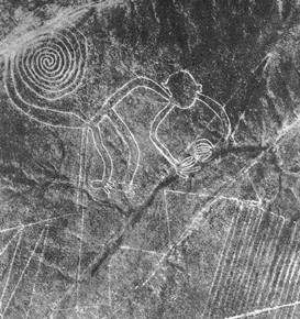
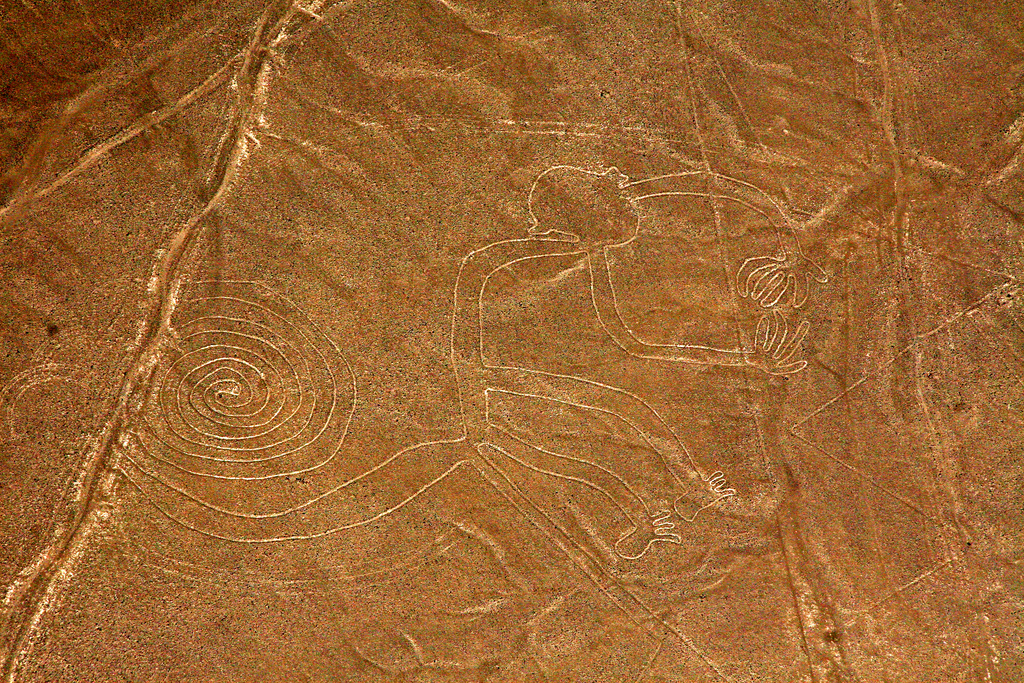
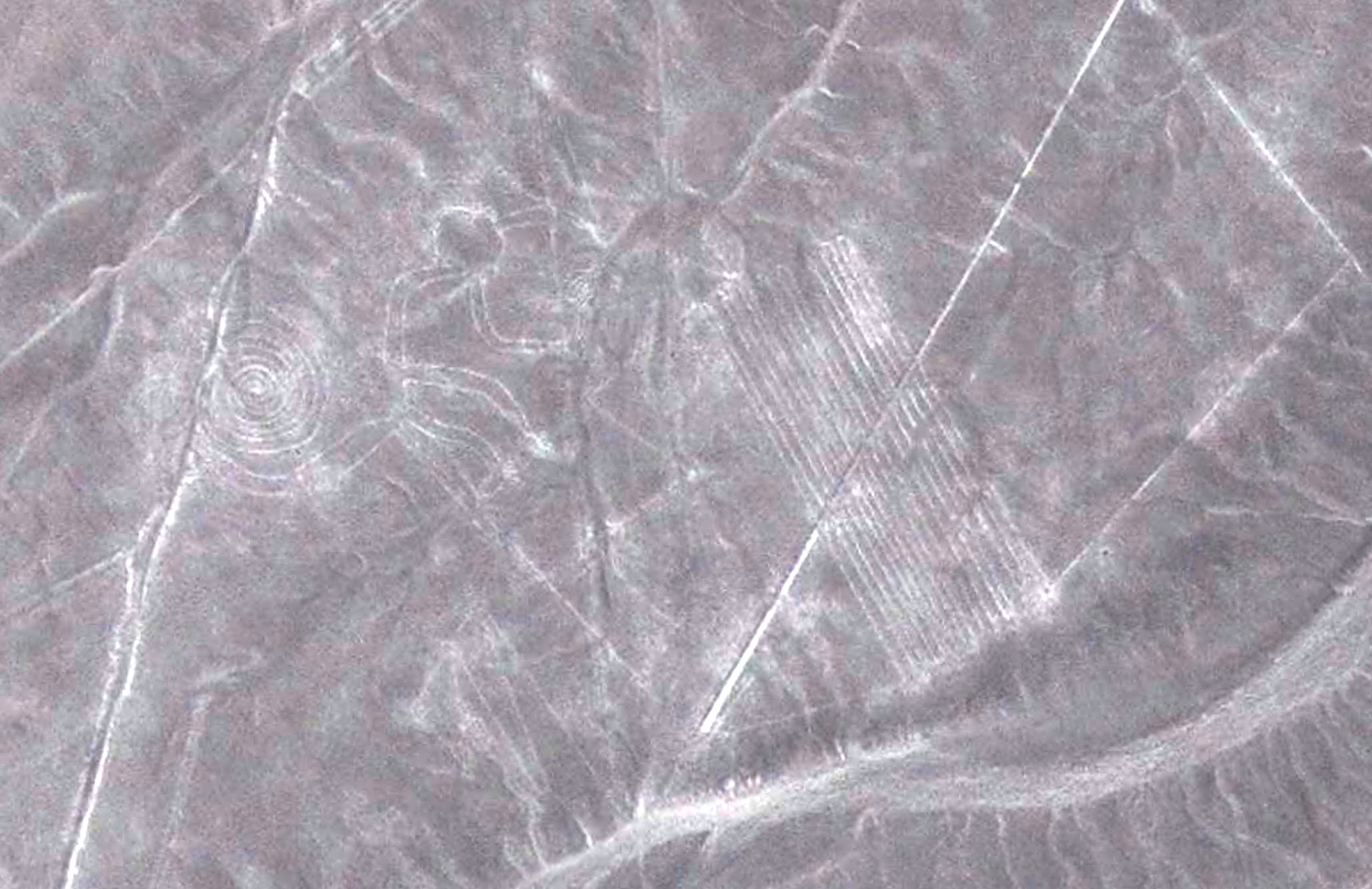
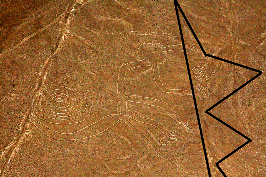
Nasca monkey
This is one of the geogliphs that we can find in Nasca. Let's take a look at it. Interpretation of it, is quite difficult, if we do not consider the symbols that go with it. That's why we should avoid cropping the monkey out of the complete drawing. People, usually make this kind of mistake as well as archeologists, specially when they try to concentrate on something specific, and easy pictograms make them say "Monkey", and that's all. I believe there is much more to say about this monkey, and connections that will astonish you.
Here are the theories:
Theories
=Toribio Mejia Xespe, a Peruvian doctor and anthropologist was the first
scientist, in 1927, to show interest in what he called "great Incan ceremonial
artifacts".
Michael Coe believes the Nazca Lines are sacred paths to walk by specific rites.
The primary lines were an offering for elders, heaven, and mountain deities who
gave them water for their fields.
Erich von Daniken suggested, in his 1968 book, Chariots of the Gods, that the
lines were built by ancient astronauts as a landing strip. But the soft clay
soil and layer of brown and black rocks in the Nazca desert would seem an
unsuitable site for landing and were blown away by the power of rocket
propulsion. The aliens left - never to return - leaving the people confused.
Like in the modern cargo cults they tried to call the Gods back by drawing lines,
figures and trapezes.
Robin Edgar beieved that the Nazca Figures were inspired by, and intended to be
seen by, the (so-called) Eye of God that is manifested during total solar
eclipses. An extraordinary series of solar eclipses coincided with the
construction of the Nasca lines. Some Lines are aligned with the winter solstice,
a less spectacular but more regular, death and rebirth of the Sun God.
The Code of Carl Munck - The Ancient Geomatria of Numbers --The Nazca Line
ground markings locate themselves on The Code Matrix system. Nazca Lines and
Archaeocryptography The ancient sites around the world are very precisely
positioned on a global coordinate system in relation to the position of the
Great Pyramid at Giza. The positions of the sites are given in the geometry of
their construction. A very ancient system of numbers was used in the system,
which we will call Gematria. Gematrian numbers are found in ancient myths and
religions, including the Bible. Gematrian numbers were used in systems of
weights and measures by ancient peoples, including the Greeks, the Egyptians,
the Persians, the Babylonians and the Romans. The Code system uses mathematical
constants, such as pi and the radian. The system also uses conventions that are
still in use, such as the 360 degree circle, 60 minute degree, 60 second minute,
the base-ten numbering system, the 12-inch foot, and the 5280-foot mile.
The ancient Mayans used Gematrian numbers in their very accurate timekeeping.
Maria Reiche was a German mathematician and archaeologist who was famous for
researching the Nazca Lines. She believed the lines were an Astronomical
Calendar indicating the direction of the rising of important stars and planetary
events like sun solstices. Formations like the spider and the monkey could show
star constellations like Orion and Ursa Mayor. The problem with all astronomical
theories is the unknowing of the age. The direction of stars changes within
centuries, explained by the precession of the equinoxes.
Reiche led a determined effort to discredit theories of extraterrestrial
visitors. She argued that the Nazca Indians constructed the Lines some time
between 300 BC and AD 800. In support of this possibility, some scientists have
put forward ingenious ideas on how the geoglyphs could theoretically have been
designed from the ground. The more important evidence, however, is that which
attempts to link the Lines definitively to the Nazcan culture. Here, neither of
the two key pieces of evidence survive close scrutiny.
The first piece of evidence is a series of radiocarbon dates, based on ceramic
and wood remains which were left at the Lines by the Nazca people. It is claimed
that this proves that the Nazcans constructed the Lines. On the contrary, the
dating of these materials tells us only that the Nazcans lived in the area of
the Nazca Lines. Since the Lines themselves cannot be radiocarbon dated, the
possibility remains that they already existed when the Nazcan culture emerged.
The second piece of evidence is the alleged resemblance of the Nazca geoglyphs
to certain features found on Nazca pottery. This is an important issue because
it potentially offers proof that the Nazcans had either designed the images or
at least viewed them from the air. Maria Reiche died in 1998 at the age of 95.
She is buried in the arid valley she loved so well.
Professor Gerald Hawkins and his group went to Nazca to prove the astronomical
Theory of Maria Reiche but was unsuccessful. In 1968, a study by the National
Geographic Society determined that, while some of the Nazca lines did point to
the positions of the Sun, Moon and certain stars two thousand years ago, it was
no more than could be expected by mere chance. In 1973, Dr Gerald Hawkins
studied 186 lines with a computer program and found that only 20 per cent had
any astronomical orientation - again no more than by pure chance.
Simone Waisbard stated that the drawing of Nazca are a giant astronomical
calendar. Further the Nazca-line-system was used to measure the precipitation
value. Figures, especially seabirds, have a connection to the meteorological
prophecy system of the Nazca-Culture. Her ideas for the trapezoid formations:
places for holy animals before sacrifice them, or field claims connected with
filter galleries, observatories or places for ritual ceremonies of the different
clans.
Alan F. Alford concluded that the Nazca-Lines was made by Negroid Slaves of the
Tihuanaco Culture. After a revolution the Negroid population destroyed some
figure, this is the explanation for overdrawn zigzag-formations. Later this
people went in northern direction and founded Chavin and the Olmec culture.
Robert Bast linked the lines to the Flood Stories in his book A Memory of the
Deluge. The animal, plant and human-shaped figures are lying together on the
ground as a memorial place of the big flood.
Gilbert de Jong wrote A Nazcan Zodiac. He traveled to Nazca and measured the GGF
by GPS. He obtained a length of the square side of about 54,7 Meter. In the
formation he recognized a Zodiac.
Markus Reindel's Dowsing Theory says that the Nazca Figures are markers for a
subterranean waterflow. Trapezoides show the broadness of the waterstream,
zigzaglines show where they end, lines show into direction of the puquitos. He
explain the nature of the figures by rod-dowsing (to find the subterranean
water) and shamanstic flights (to overview the figures).
Nazca Culture - Cahuachi People
On the pampa, south of the Nazca Lines, archaeologists have now uncovered the
lost city of the line-builders, Cahuachi. It was built nearly two thousand years
ago and was mysteriously abandoned 500 years later. New discoveries at Cahuachi
are at last beginning to give us insight into the Nazca people and to unravel
the mystery of the Nasca Lines.
In general, Nazca culture is considered to consist of three stages; Early,
Middle, and Late stages, and also the Classic Nazca (approximately A.D.
250-750). One of the most famous and distinctive features of the Nazca culture
is the polychrome pottery which has attracted attention because of its
technological refinement and the exciting symbolism of its motifs. This pottery
culture spreads in the area of the valleys of Chincha, Pisco, Ica, Nazca and
Acari.
In the Early stage, these wares did not have much color, but Middle and Late
Nazca polychromes are buff or red and are painted in three to eight colors. The
most popular choices of color were red, black, white, brown, yellow, gray and
violet with an outline in black. Bowls and beakers were common forms, but
double-spout and head-and-spout jars are also found. Birds, fish or fruits were
commonly drawn on the pottery, and Nazca's religious or mythological features
were also used in its design.
Cahuachi, in Peru, was a major ceremonial center of the Nazca
culture and overlooked some of the Nazca lines from 1 CE to about 500 CE.
Italian archaeologist Giuseppe Orefici has been excavating the site for the past
few decades, bringing a team down every year. The site contains over 40 mounds
topped with adobe structures. It has also been studied by Helaine Silverman, who
has written a book on Cahuachi.
The permanent population was quite small, but it was apparently a pilgrimage
center that grew greatly in population for major ceremonial events. These events
probably involved the Nazca lines and the giant sand dune of Nazca. Support for
the pilgrimage theory comes from archaeological evidence of sparse population at
Cahuachi and from the Nazca lines themselves which show creatures such as orca
and monkeys which were not present in the Nazca region. Of course, trade or
travel may explain the images. Due to the dry climate the finds are quite rich
and include even such ephemeral material as clothing.
Looting is the greatest problem facing the site today. Most of the burial sites
surrounding Cahuachi were not known until recently and so present a very
tempting target.
Some of the Nazca Lines, mysterious geoglyphs that span a vast swath of the rugged Peruvian desert, may have once been a labyrinth with a spiritual purpose, a new study suggests. At the time the Nazca Lines, which span 85 square miles (220 square kilometers), were drawn, people were not looking at this stuff from the air, they were looking at stuff from the ground level. To appreciate what they might have meant to ordinary people, then you have to walk them.
The ancient Nazca people of Peru are famous for the lines they
drew in the desert depicting strange animal forms. A further mystery is what
happened to this once great civilisation, which suddenly vanished 1,500 years
ago.
Here are the coordinates of the biggest geogliphs you will find in the Nazca
area.
Title Lat Lon Style psize name
Nazca Lines -14.68833334 -75.12277779 30525
Nazca culture -14.68833333 -75.12305556 18399
Nazca Lines -14.75 -75.25 16045 arrow
Nazca -14.828889 -74.943611 landmark 8804 Nazca
Nazca Lines -14.75 -75.25 8471.5 arrow
Nazca District -14.83277778 -74.93611111 8023
Nazca Plate -14.82888889 -74.94361111 city 7758
Cahuachi -14.81307778 -75.14616389 mountain 6580
Nazca Province -14.828889 -74.943611 adm2nd 6067
Geoglyph -14.69222222 -75.14916667 landmark 5730.5 Nazca
Around the World in 80 Treasures -14.7222639 -75.15950001 4966.25
Palpa, Peru -14.53393333 -75.18548333 city 3668
Palpa, Peru -14.534031 -75.184964 landmark 3255 Palpa
Maria Reiche Neuman Airport -14.85416667 -74.96111111 airport 2657
Palpa Province -14.534031 -75.184964 adm2nd 2632
Nazca Lines -14.69229722 -75.14918889 landmark 1723.0909 Nazca Kolibri
Nazca Lines -14.69758333 -75.1264 landmark 1723.0909 Nazca Kondor
Nazca Lines -14.68841667 -75.12308333 landmark 1723.0909 Nazca Spirale
Nazca Lines -14.69427778 -75.12266667 landmark 1723.0909 Nazca Spinne
Nazca Lines -14.70694444 -75.13869444 landmark 1723.0909 Nazca Affe
Nazca Lines -14.74522222 -75.07975 landmark 1723.0909 Nazca Astronaut
Nazca Lines -14.69411111 -75.11483333 landmark 1723.0909 Nazca Baum
Nazca Lines -14.69355556 -75.11477778 landmark 1723.0909 Nazca Echse
Nazca Lines -14.69461111 -75.11422222 landmark 1723.0909 Nazca Hände
Nazca Lines -14.68997222 -75.10708333 landmark 1723.0909 Nazca Papagei
List of World Heritage Sites in the Americas -14.72583333 -75.14861111 landmark
939.7222 Lines and Geoglyphs of Nazca and Pampas de Jumana)
75th meridian west -14.63333333 -75 adm1st 176.8636 Ica
List of populated places in Peru -14.53361 -75.18556 120.7391 Palpa
List of populated places in Peru -14.51972 -75.20139 120.7391 Río Grande
List of populated places in Peru -14.83333 -74.95 120.7391 Nazca
The hundreds of individual figures range in complexity from simple lines and
more complex geometric lines to hummingbirds, spiders, monkeys, fish, sharks,
orcas, llamas, and lizards. Wikipedia entry on Nazca lines provides some more
detail: “the Monkey is 93 meters (310 ft) by 58 meters (190 ft), and the Spider
is 47 meters (150 ft). The extremely dry, windless, and constant climate of the
Nazca region has preserved the lines well. The Nazca desert is one of the driest
on Earth and maintains a temperature around 25 °C (77 °F) all year round. The
lack of wind has helped keep the lines uncovered and visible to the present day.”
Figures are still being discovered, and there are many universities who continue
to study them. It’s amazing you can see them from google maps. Search for “nazca
lines” and it will put you nearby the spider. Zooming in and out you can see
some of the geoglyphs are marked.
We also visited an island Taquile in the middle of Lake Titicaca that is another unique culture. There are a couple of other islands in this highest freshwater lake at 3,800 meters above sea level. 50 miles wide 130 miles long. “The society of Taquile is still based on collective work and the Inca moral code “Ama sua, ama llulla, ama qilla” (do not steal, do not tell lies and do not be lazy). Taquile is best known for its textiles, the finest crafts, not only in Peru, also in the world.” Hand weaved by 80+ year old men.
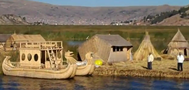
Uros floating Island: I have discovered that they are connected
to Shardanas and Sumerians, but I will show you my research and findings in
detail later on.
"We know who drew these giant shapes in
Peru's desert - but why?"
December 10, 2007, The Miami Herald, USA:
"Everyone here, it seems, has a theory about the Nasca Lines. The mysterious
markings on the desert floor are a massive astronomical calendar. That's a
popular one.
Or maybe they point to hidden reserves of water, the source of life in the
desert.
Then there's my favorite: UFO landing site. Forty years ago, Danish writer Erich
Von Daniken popularized that theory with his best-selling book Chariots of the
Gods?
Now, strapped into a four-passenger Cessna circling over a figure called the
astronaut, I'm not sure what to think. One of its hands points to the sky,
another to the ground. His owlish eyes stare into mine. Look at me, the
1,500-year-old seems to say. Can you solve my mystery?
Here's what's known: For hundreds of years, the Nasca people created lines on
the ground. Some form familiar figures: a spider, hummingbird and dog. Others -
a whale, monkey and parrot - don't belong in the desert at all.
The only way to see the Nasca Lines is from the air. That makes them even more
mysterious. How did pre-Inca people make these images without being able to fly?
And what was the point of forming lines if they couldn't appreciate their glory?
The lines weren't even discovered until 1929, when a pilot flew over the area
and was astonished to see eyes looking up at him.
Thanks to the ancients, the town of Nasca now has a veritable air force: More
than a dozen companies fly planes over the lines. The tours are an industry, as
indicated by the handwritten sign taped to my plane's instrument console. 'Tips
are welcome', it says in six languages.
Not bad for a dusty desert town of about 20,000, a six-hour bus ride south of
Lima. The modern city of Nasca, a place that gets less than an inch of rain a
year, owes its prosperity to the mysterious markings. Statues inspired by the
desert figures decorate the town plaza. Sketches of the lines are everywhere
else. Elongated hummingbirds mark store signs, while a lizard graces City Hall.
On sidewalks, brass inlays of a monkey and spider reflect the sun.
But the lines might have been forgotten without Maria Reiche. She came to Peru
from Germany in the 1930s as a tutor and eventually dedicated her life to
documenting the creations. For years, she surveyed the area, measuring the
markings and pondering their meaning."
- Read this article now.....
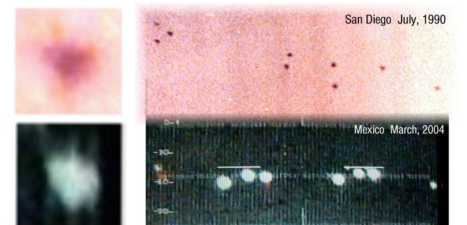
Mystery Triangles Break Nazca Code
An amatuer photographer in San Diego has the local press convinced he's solved
the riddle of who made the famous lines on the desert floor at Nazca, Peru. Ten
UFOs he accidentally captured in a single photograph apparently contained the
rosetta stone to finally solve this ancient mystery and his popular website
backs him up with evidence the Los Angeles Times labeled "UNSETTLING".
August 27, 2004
It was just another hike thru the woods for three friends in San
Diego on that glorious July day back in 1990. Only after the photos from the
trip were developed did the hikers discover they were not alone.
In the distant background of one of those daylight scenic photos, a formation of
nine objects were accidentally captured hovering over a nearby hillside. "THESE
EXTRAORDINARY PHOTOS ARE MOST PURSUASIVE EVIDENCE OF THE EXISTENCE OF UFOs" an
expert would claim months later in a popular magazine. On the trail that day
however, nothing was out of the ordinary as the three adventurers set out to
explore for the first time a beautiful loop trail at Inaja Memorial park in
Santa Ysabel, California just east of San Diego.
It was at scenic spot number seven on that loop trail that the historic photo
was taken with a Canon EOS 650. Lacking a tripod the photographer rested the
camera on the top of a manmade rock wall that was built to honor 11 firefighters
who lost thier lives battling a fire there November 25 1956. Michael, the
photographer, had pointed out the date of the fire to his girlfriend Ronnie and
buddy Bob when they first examined the memorial marker at the entrance to the
park. They looked at each other in amazement knowing that Mike was born one day
later.
The rock wall at scenic spot seven also supported a periscope device that
described what mountain the viewer was looking at by an indicator on the bottom.
The three hikers were overwhelmed at the site by the majestic beauty of the San
Diego river valley stretching away for eighteen miles as it made its way to the
Pacific Ocean. Looking through his cameras viewfinder Mike set the lens on
maximum focus, exhaled, and gently squeezed the shutter button.
With the sun setting fast to the west and no idea how long the trail was the
three friends departed quickly but that last photo was still blazing in the
photographers mind as he led his group back to the car. It was the unearthly
blue glow from the late afternoon haze as it blanketed the valley and
surrounding hillsides that he could'nt get out of his mind as they drove away
from the magical park. No one could have guessed what secret the camera was
holding during the long ride home.
A week later the photos were ready at Thriftys and as Michael flipped through
them the "scenic spot seven" photo leaped out but there was something strange
about it. In the upper left background of the photo were nine hovering
triangular objects stretching to the right (west) and across the valley another
similar object was captured on film. At first the photographer thought it was a
developing error and looked for the anomaly on any of the other photos from the
trip but found none.
Even without a loop you could see the objects were reflecting the setting sun
above and the blue atmosphere below them. Only after one of the photograhers
friends labeled them ducks did Mike have the objects professionally blown up to
grain which set in motion a series of discoveries and events that would later
produce numerous front page articles, dozens of radio interviews around the
world and several spots on local TV. It may also have changed the science of
UFOlogy forever.
"MYSTERY TRIANGLES ARE ALIEN CRAFT,SAY EXPERTS" read one headline while another
boldly proclaimed "IT'S LIKE MARTIANS MAN". After having the "Inaja UFO Photo"
blown up to grain, it was discovered that the single object hovering in the
right side of the photo was actually moving left towards the formation. More
importantly the left contour of the object not only matched the acorn shape of
the famous "Kecksberg" UFO but contained a spike like projection two thirds up
the left side that exactly duplicated the images on the Nazca plain as seen in
Marilyn Bridges book "Markings"on pages 9 and 27.
Within three months of taking the photo at Inaja, Mike claims to have found the
same projecting triangles not only at Nazca but in countless ancient rock
paintings ,crop circles, ancient artifacts and, oh yes, other UFOs. Labeled "San
Diego's Premier UFO Enthusiast" by the L.A. Times, his remarkable discoveries
appear to be far ahead of their time as the scientific community has largely
ignored them and the articles have all but dried up. Like a time capsule in
space, however, a revealing website with "UNSETTLING" evidence, now heralds the
good news to thousands that WE ARE NOT ALONE.
No other place in the world can stir up imagination and
curiosity of scientists, mystics, and common people alike in such a way. No
other place in the world gave rise to hundreds of rumors and speculations. The
place is called the Nazca desert. It is located in Peru. The so-called Nazca
Lines are among the most wonderful and inexplicable evidence of an ancient
civilization that was totally different from our civilization. Despite
painstaking research conducted by many scientists of note, Nazca remains "the
most enigmatic picture book in history of mankind."
The lines and drawings of the mysterious desert were discovered only in 1927
after the first airplanes began flying in the Peruvian sky. In 1939, the
American professor Paul Cosock was flying in his light aircraft over the desert
in the Rio Grande valley. He could hardly believe his eyes when he saw a giant
stylized picture of a bird down below in the desert. A line that seemed
incredibly straight was drawn next to the bird. The line cut through the
irregularities of the relief and hid behind the horizon. Later more lines were
found in the desert. Some were set in a parallel pattern, others formed
geometric and other figures measuring from 60 to 250 meters. One could see a
giant spider, a monkey with a spiral-like tail, a whale, a dog etc. The top
attraction was drawn on a gently sloping side of the mountain. It was a giant
man wearing heavy boots, his head was big and his round eyes would befit an owl.
And his arm was raised as if in greeting.
It took years to study the phenomenon. The unusual place attracted extraordinary
characters. The eccentric Erich Von Daniken, the author of the well-known "Memories
of the Future," claimed that Nazca was a refuel station for intergalactic
spaceships. Jim Woodman, an aeronaut, narrowly escaped death while performing a
dangerous experiment to prove that ancient Peruvians could fly balloons. Maria
Reihe, a mathematician by profession, became the most striking symbol of the
Nazca desert. Equipped with a simple sweeping brush, the woman had been sweeping
the desert clean for more than 50 years. She was apparently doing that in an
attempt to unravel the mystery of the red sands. The desert became, without
doubt, her destiny.
Maria first arrived in the desert along with the discoverer of mystic lines Paul
Cosock. She worked as an interpreter for him. She stayed on location when the
researchers went back to the United States. Maria devoted her life to the study
of strange lines. Her daily work was titanic and she did not get paid for doing
it. She spent hours hanging overboard the plane in a makeshift rope basket while
photographing the Nazca lines and drawings at the risk of her life. Thanks to
her immense persistence, the desert lines were preserved and finally granted
protection by the Peruvian government. Her contribution to the study of ancient
culture can not be overestimated.
The Peruvians called her the "mother of the desert." However, the desert never
revealed the mystery to its most ardent devotee.
Honestly, I think that it is not so much racism or ethnocentrism
as it is the assumption that ancient cultures were somehow more spiritual then
we today are and were capable of a myriad of spiritual practices. This
phenomenon is hardly new - the concept of the 'noble savage' in tune with
untapped realms of spirituality can be seen throughout the history of European
exploration and colonisation (Reference).
As for the Nazca lines themselves, I wholeheartedly agree with dave_54 that they
were almost certainly envisioned and planned before their actual construction
and then were actually created through the use of a grid system. For an example
of how such a system might work, and to learn how to make your own geoglyph or
biomorph, check out this article at The Unnatural Museum.
Although no advanced technology or spiritual connection would have been
necessary to construct the lines at Nazca, their construction was no small feat.
Constructed by (surprise, surprise) the Nazca peoples, who lived in the region
between 200BCE and 600BCE (Reference 1 (Skeptic's Dictionary); Reference 2 (Wikipedia)),
the lines include not only literal straight lines:
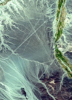
A satellite view of the Nazca region showing the straightness of
some of the lines.
but also depictions of geometric shapes, humans and animals, including a
hummingbird, spider, lizard and monkey, to name but a few:

This monkey from the Nazca region is deformed - it has four fingers on its right
hand and five on its left.
The actual process by which the shapes were made was incredibly simple - the
Nazca people simply removed the iron-rich rocks, stones and dirt to reveal the
lighter coloured subsoil. A lack of serious rain in the region has allowed the
shapes to stay virtually intact to the present day:
This photograph, taken at ground level, demonstrates the process
used to construct the Nazca lines.
The one aspect of the Nazca lines which I personally find much more interesting
then how they were built is why they were built - what purpose did they serve?
Setting aside the implausible notions of an airport for visiting alien craft, we
are left with a number of intriguing possibilities.
Theories in the past have included: the lines were used for running footraces.
This seems highly improbable, given that the construction of the lines was a
monumental undertaking that would have taken hundreds of years (Reference (Skeptic's
Dictionary)). Another theory is that the shapes represented an enormous calendar
by which the Nazca people could keep track of the seasons and, subsequently,
important agricultural dates. Whilst this seems more plausible, it is difficult
to prove given the fact that, with so many lines and shapes and formations, it
would be almost impossible not to observe some form of astronomical alignment
purely by chance. Lacking a written explanation by the builders themselves, we
simply do not know. Indeed, in 1968, an American astronomer, attempted to
calculate how many of the lines coincided in alignment with significant
astronomical events. He found that the number that was significant was only
equal to the number that would have been significant through chance alone (Reference
1 (The Unnatural Museum); Reference 2 (Global Water Partners)). A more recent
theory argues that the shapes and lines were built to mark the presence of
faults which may control groundwater. You can read more about this theory at the
Global Water Partners Nazca Lines page. Their site states their hypothesis in
the following terms:
ersonally, I am interested in the actual depiction of the animal figures. It occurs to me that, given the care and time and manpower that went into constructing them, why do some of the figures look the way they do? The monkey, for example, is deformed. This may have been accidental, but surely if everything was mapped out before construction began it is not unreasonable to assume that the deformity was deliberate. It just seems to me, on a purely aesthetic level, that the figures seem deliberatley surreal or even terrifying.
Good speculation, Jeremiah.
The notion of 'UFO airports' is silly. Ever see a spiral runway? And why would
aircraft capable of interstellar flight need a runway anyway? Anyone needing a
picture of a monkey or whale to land an aircraft cannot be a very advanced
civilization.
I think they were just religious icons. A means of honoring the gods and
imploring their graces. Deities living in the sky is a cultural universal found
around the world (and it has nothing to do with extraterrestial visitors). The
sky was an unachievable location. You can cross large bodies of water, walk
great distances, and climb tall mountains, but no matter how you tried, you
could not visit the sky. So the sky became something sacred and the gods live in
sacred locations. They attempted to communicate with the gods they only way they
knew -- with big pictures visible from above. The pictures were of things they
knew and had cultural significance to them. Was a four fingered monkey part of
an old legend or mythology? That is speculative, but possible. It could explain
the riddle.
Even in contemporary culture 'Heaven' is often thought of as, well, up in the
heavens. (It is not up there, of course. In contemporary theology Heaven is not
a physical place but a state of being.)
Ancient, Giant Images Found Carved Into Peru Desert
Human and animal likenesses, a knife, and a sundial are among
the "geoglyphs," or giant figures etched into the earth and discernible from the
sky, most recently discovered in the Peruvian desert.
Peruvian archaeologist Johny Islas and German colleague Markus Reindel have
identified new etchings made by the ancient Nasca people in the desert valleys
of Palpa, about 460 kilometers (290 miles) south of Lima. After five years of
work, the scientists were able to identify more than 1,000 new geoglyphs.
The Nasca, whose culture flourished from around 200 B.C. to the middle of the
seventh century A.D., made many of their etchings near the city of Nazca.
But the glyphs identified by the two archaeologists in Palpa, 40 kilometers (25
miles) north of the city, predate the geoglyphs previously discovered and appear
to mark the beginning of that civilization.
Thanks to aerial photographs, the researchers were able to identify 650
archaeological sites as well as thousands of geoglyphs, petroglyphs, and
cemeteries left by the Nasca people.
Islas and Reindel also found planks with etchings similar to the enormous
drawings previously discovered in the desert sands.
"The technique is simple," Islas said. "The straight lines are traced with
stakes attached with a string. The difficult part is translating the figures to
the large scale while maintaining the correct proportions." The Nasca people
created more than 1,000 figures of varying sizes, from a sundial 150 meters (500
feet) long to whales, foxes, and pelicans of 40 meters (130 feet) in length.
They also etched human figures, apparently representing a family, each measuring
30 meters (100 feet) long.
The Nasca created these immense figures in an effort to differentiate themselves
from their predecessors, the Paracas, whose art was on a much smaller scale.
The geoglyphs in the Palpa valley provide evidence that a new culture emerged in
the region near the start of the Christian era, bringing with it new methods of
building settlements and a new ideology.
The etchings in the desert make up a sacred landscape honoring water and
fertility.
The cultural changes evident from the geoglyphs have also been noted by
scientists studying the more than 600 archaeological sites in the region.
"We searched some tombs and in each we found funeral shrouds,
vessels, shells, and necklaces made of semi-precious stones, but more
importantly we found gold objects" similar to the giant whale figures etched in
the desert, Islas said.
"The valleys of the south are not like those in the north. The south was a very
dry region, almost an oasis. They only had water in the summer, and the
accumulation of wealth was difficult," he explained.
"But the Nasca managed to organize a society and take advantage
of resources from the ocean and the mountains. They were truly an advanced
society," he added.
The tombs, located in two sites that were large administrative centers during
the first four centuries of the Christian era, have revealed important
information about the environment, lifestyle, and religion of the Nasca.
Each tomb is composed of several rectangular chambers with a labyrinthine
structure of walls and passageways dedicated to the cult of the dead, where
people left offerings and prepared food to sustain the deceased in the afterlife.
The buildings were adapted to the topography of the region, creating a large
complex of terraces.
- Back to Nazca: just paste the coordinates into Google Earth
How would you explain such awesome archeology?
Use these coordinates to "go look for yourself" via Google Earth. Just paste
into search field. Then zoom, pan, flyover, check out the topography, place your
pins to navigate, etc.
The hummingbird
-14.692157,-75.14888
The Monkey
-14.706900,-75.138371
The Astronaut (or Giant)
-14.745218,-75.079748
The Pelican
-14.689693,-75.107748
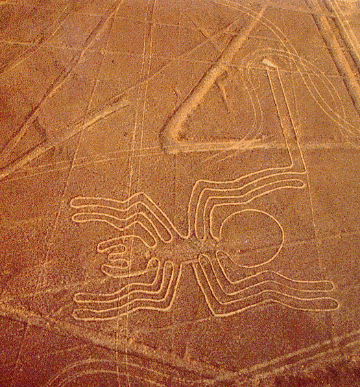
The Spider
-14.694144,-75.122372
Four OSL ages were also obtained at the Sacramento site (Figures
2 and 4, Table 1). Two samples yielded ages in close agreement with each other:
Sac 4 (from beneath a large
stone) gave 1470+ −420 years ago and Sac 3 (from a stone accumulation pile) gave
1330+ − 290 years ago. Another sample (Sac 1) from a stone accumulation pile
gave a much older age
of 2380+ − 390 years but the small number of aliquots, the strong scattering of
the De values (Figure 7) and the problematic preheat plateau data (Figure 6)
provide little confidence in
this result. The sample of the undisturbed desert surface (60-80mm depth) gave
an age of about 12 000 years, which strongly suggests the source of the grains
was mainly in situ
breakdown of partially exposed rock fragments or downward movement of grains
into the desert pavement that had been exposed to light by much earlier events.
Figure 8 presents a
graphic summary of the dating results.
Studies of the sediments taken within 3mm of the bottom of the large stone at
Sac 4 showed very large doses of 20-40Gy, consistent with contamination of the
sediments with grains
resulting fromthe breakdown of the large stone immediately above. Aliquots with
these large doses were excluded from the age calculation.

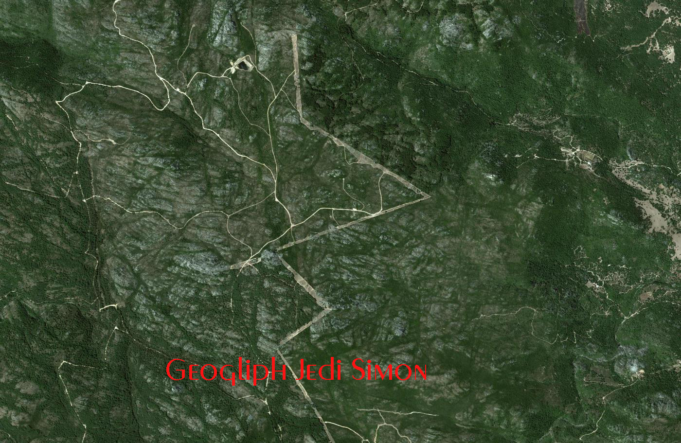
Now, I would like to present You what I just
discovered. Take a look at
the symbol that is standing next to the Monkey. What is it? No answer? I believe
that it is at the same time a geoglyph,
the pictogram of the concept of
friendship, between Men and Aliens ( 4 and 5 fingers ), an the symbol of an ancient
civilization. It was used as a geological instrument to communicate, an antennae,
tuned on
this configuration.
These lines, that can be detected from the sky very easily, because of their
resonance, expecially using infrared scanners or echo scanning, will show to the
departed ones, where friends are.
I am asking you to concentrate on abstract symbols that you may have not
considered as important as the symbols of the animals themselves.
Build a circuit of this kind and see what happens. Now make a bigger one. Just listen. Find the same pattern somewhere elese. You will find interesting connections that you have missed.

Say Hello!!!
This is a Geological Communication System probably based on
resonant natural circuits that work like antennae. Look at
the complexity of this system.
How many they made, and just try to figure out how it worked from a scientific
point of view. Is is not to difficult. Use imagination.
And now, try to find the same symbol elswere, of the same size, or even smaller
or bigger, following the physics of wave propagation and antennae.

You will need satellite imagery and very good scanners to find out the key of this puzzle, but nevertheless, it is embedded in the pictograms themselves, proportions and angles. Decode it.

Numbers will give you the answer, though the pictogram says that
four fingered and five fingered ones are linked together and come from the same
offspring.
Another antennae.
From the sky. Total scheme.
This is the a partial
section of the geogliph we are considering at the moment. I won't give You the
solution, right now, so just try to find it by Yourself if you are curious...
I would advice You to take a look at
the night sky and try to find the right constellation. When you find the answer,
send me an e-mail, and I will tell You if it is the right one.
Look for the stars, unite them, and
this symbol will tell you where the Monkey's star is. You will find it's freinds
there.
Anyhow, even if you don't think that
what I am saying is true, I can tell You that they left signs here and there all
around the world. Even bigger ones.Much bigger ones. Prove it. Ok
I will show you one. A 7 km one. This
geogliph is the bigger version of the Nazca Monkey one, but there exist
geogliphs that in comparison are 10 to 100 times bigger than the ones we know.
Just trust me. Here it is.
Jedi Simon